Show summary Hide summary
Summary:
- An itinerary mixing natural wonders with local legends.
- Safe and practical ways to explore waterfalls, glaciers and volcanic zones.
- Insights into early settlers and modern geothermal sites.
- A smooth route linking Reykjavik, Vík and hidden inland valleys.
Iceland has a way of surprising you before you even understand why. On this south-coast route, the scenery shifts often but never abruptly; quiet farms, grassy plains, wind-carved cliffs and glaciers that suddenly appear on the horizon. Nothing feels staged, everything seems part of a larger rhythm shaped by time and weather.
This guide walks you through that rhythm. It highlights stops where the landscape speaks for itself, where the ocean demands respect and where people live with volcanoes as calmly as others live with seasons. If you want a clear and grounded way to explore the south of Iceland, this route is worth following.
Solo female travel: a simple guide to feel safe, social, and fully yourself
Lascaux IV in 2026: the 10th anniversary dates worth planning around
Into the soft-rock caves of Hella: a quiet opening chapter
Your journey begins in Hella, where the man-made caves of Ægissíða offer a first contact with Iceland’s early settlers. They are believed to have been carved by Irish monks long before Norse arrivals. The idea seems unlikely until you step inside; the curves in the sandstone, the marks on the walls and the soft echo under the arching ceilings feel unmistakably shaped by hand.
What you will notice inside
- Smooth walls carved with symbols and simple drawings.
- Rooms used for storing food or sheltering animals.
The visit is short and grounding. A tasting room nearby serves local gin and beer brewed only a few steps from the caves, adding a warm and unpretentious touch to this first stop.
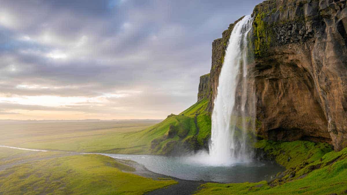
Two striking stops: Skógafoss and the black shore of Reynisfjara
Skógafoss is the kind of waterfall that does not need an introduction. You hear it before you see it, then suddenly it fills your entire frame of vision. The farmland behind the mist gives the place a humble and lived-in feel rather than a simple postcard view.
Local tip
Arrive early if you can. The morning light softens the spray and the falls stay calm and quiet until mid-day.
Reynisfjara is a complete change of mood; soft black sand, sharp basalt columns and a shoreline that demands caution. The waves often break with surprising force and can move quickly up the beach.
What this means for you
- Keep a safe distance from the water.
- Respect the warning signs at all times.
Take a moment to observe Reynisdrangar, the rock pillars tied to old coastal legends. Together, these two stops show the south coast at its most raw and expressive, without forcing anything.
Vík and the Katla geopark: life near active volcanoes
Vík may seem small at first glance, yet it holds a quiet energy. It sits inside the Katla UNESCO Global Geopark, a region where glaciers rest on top of active volcanic systems. The red-roofed church above the village acts as both a visual landmark and a gathering point if Katla shows signs of unrest.
A stop at the Lava Show in Vík or Reykjavik helps clarify the relationship between locals and volcanic activity. Specialists melt volcanic sand to create real flowing lava, then show how it reacts to air, ice and water; the demonstration is simple, visual and accessible even if you know nothing about geology.
Quick overview
| Volcano / Glacier | Status | Key notes |
| Katla | Active | Erupts roughly once or twice per century under thick ice. |
| Myrdalsjökull | Glacier | One of Iceland’s largest ice caps. |
| Eyjafjallajökull | Volcanic system | Known for its 2010 eruption disrupting flights. |
After Vík, the road gently rises toward wilder terrain and one of the south’s most striking valleys.
Þórsmörk: river crossings, forest pockets and glacial views
Reaching Þórsmörk (Thor’s Valley) is part of the adventure. Only specialized 4×4 vehicles can make the trip, as the route crosses several unbridged rivers. The ride feels closer to a small expedition than a simple transfer; each stop offers a fresh angle on Myrdalsjökull and the surrounding ridges.
What is waiting for you
- Mountain huts, cabins and a campground for all budgets.
- A main lodge serving hot meals and offering a welcoming atmosphere.
The valley’s microclimate allows small clusters of trees to grow, a rare sight in Iceland. Trails range from gentle walks to full-day routes on the ridges, so you can choose your pace.
Hiking ideas
- Short loops for orientation around the huts.
- Trails leading to panoramic viewpoints.
- Longer routes along glacial valleys for experienced walkers.
Þórsmörk invites you to slow down, breathe and observe the south coast from a calmer perspective, with time to let the landscape sink in.
Geysir and the lagoons: unwinding before heading back
Before returning to Reykjavik, stop at Geysir, where steam and bubbling pools create a natural open-air scene. The nearby hotel serves rye bread baked for 24 hours using geothermal heat; it comes with butter, smoked fish and eggs, making it one of the simplest yet most authentic meals of the route.
Guimarães 2026: Portugal’s Green Capital you’ll actually enjoy
Greece, Croatia, Albania: three neighbors, three very different travel moods for 2026
Two lagoon options offer two styles of relaxation:
Hot spring options
- Laugarás Lagoon: warm pools and a restaurant led by chef Gísli Matt.
- Sky Lagoon: near Reykjavik, with a wide ocean view and a cold-water step.
Both spots give you room to unwind and let the last days settle in; waterfalls, black sand, volcanic valleys and long stretches of open road.This south-coast route shows Iceland as it is; grounded, simple and rich in detail. Each stop has its own rhythm; soft-rock caves, roaring waves, quiet huts and hot springs that close the loop gently. It is a route for travelers who appreciate clear explanations and places that feel lived rather than staged.